
Íomhá:Scotland topographic map-en.jpg
Size of this preview: 417 × 599 picteilín. Other resolutions: 167 × 240 picteilín | 334 × 480 picteilín | 534 × 768 picteilín | 712 × 1,024 picteilín | 2,400 × 3,450 picteilín.
Taispeáin leagan ardtaifigh den íomhá (2,400 × 3,450 picteilín, méid comhaid: 2.29 MB, cineál MIME: image/jpeg)
| Seo comhad as An Cómhaoin Viciméid. Tá an tuairisc as an leathanach tuairisc Cómhaoin a leanas thíos.
Is stór comhaid meáin Saor é an Cómhaoin Viciméid. Is féidir leat cabhrú.
|
Achoimriú
| Camera location | | View this and other nearby images on: OpenStreetMap |
|---|
| Tuairisc |
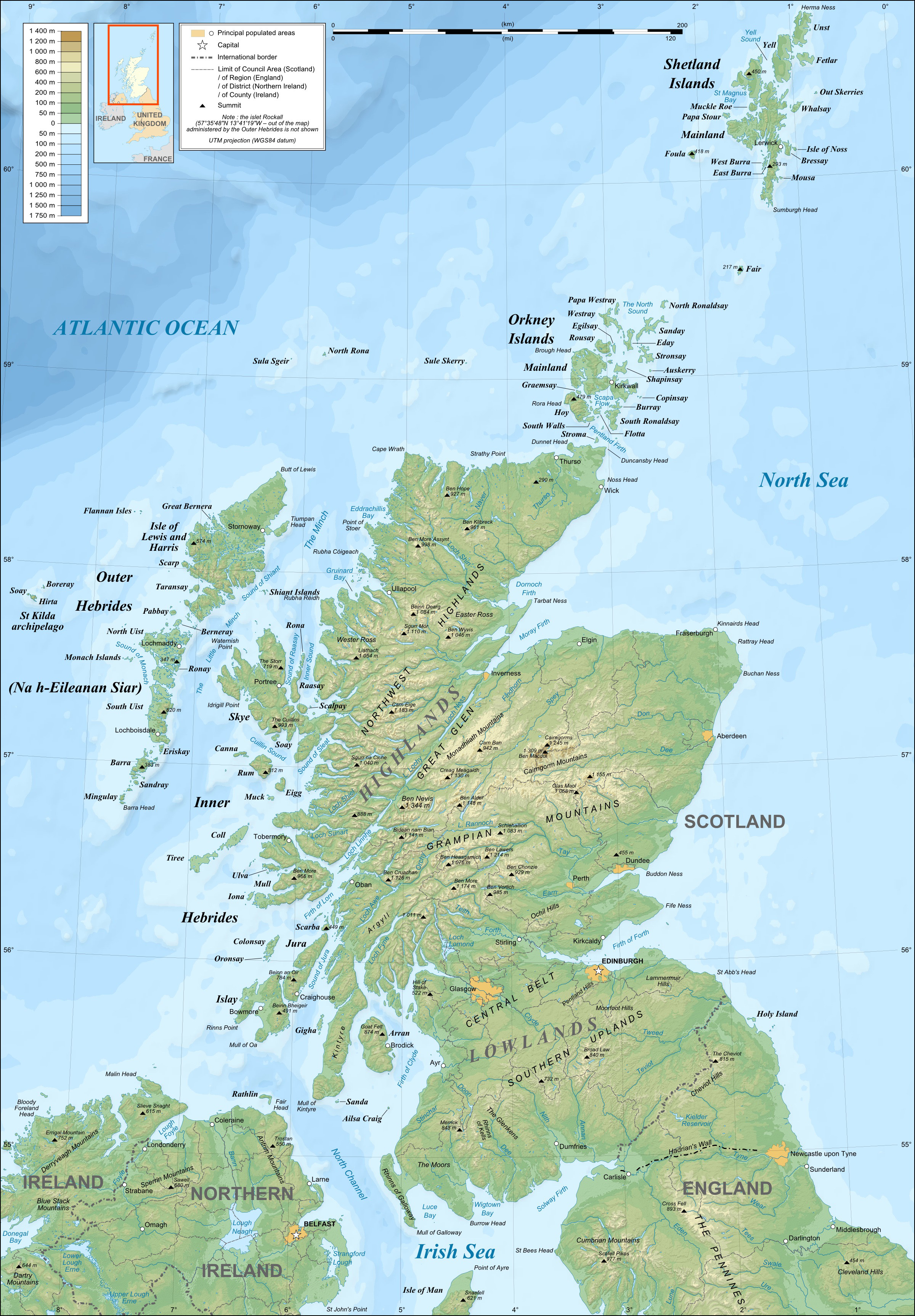
English: Topographic map in English of Scotland
This is a lighter raster JPG format version of Image:Scotland_topographic_map-en.svg which should be used in the article pages, the vector graphics version purpose being for modification and / or translation. Français : Carte topographique en anglais de l'Écosse.
Ceci est une version bitmap au format JPG et de poids de fichier plus léger de Image:Scotland_topographic_map-fr.svg qui devrait être utilisée dans les pages d'articles, la version vectorisée SVG étant destinée à faciliter les modifications et / ou traductions.
|
||
| Dáta | December 2007 (modified 09-2008) | ||
| Foinse |
Own work ;
|
||
| Údar | Eric Gaba (Sting – fr:Sting) | ||
| Ceadúnas (Athúsáid a bhaint as an gcomhad seo) |
|
||
| Leaganacha eile |
Derivative works of this file: River Forth course 3.png
[]
|


Ceadúnú
Is mise sealbhóir cóipchirt an shaothair seo agus foilsím é faoi na ceadúnais seo a leanas:

|
Tugtar cead an doiciméad seo a chóipeáil, a dháileadh agus/nó a mhodhnú faoi théarmaí an Ceadúnas Doiciméadúcháin Saor ó GNU, Leagan 1.2 nó aon leagan níos déanaí a d’fhoilsigh an Fondúireacht Bogearraí Saor in Aisce; gan aon Rannóga Inmheánacha, gan aon Téacsanna Clúdaigh Tosaigh, agus gan aon Téacsanna Clúdaigh Cúil. Tá cóip den cheadúnas san áireamh sa chuid dar teideal Ceadúnas Doiciméadúcháin Saor ó GNU. |
This file is licensed under the Creative Commons Attribution-Share Alike 4.0 International, 3.0 Unported, 2.5 Generic, 2.0 Generic and 1.0 Generic license.
- Is féidir:
- an saothar seo a roinnt – an saothar seo a chóipeáil, a dháil amach, agus a tharchur
- an saothar seo a athmheascadh – an saothar seo a oiriúnú
- Ach amháin má leantar na coinníollacha seo a leanas:
- sannadh – Ní mor creidiúint a thabhairt leis an saothar, faoi mar a shonraigh an údar nó tabharthóir an ceadúnais (ach ná húsáid modh a thugann le fios go thacaíonn sé/sí tú féin nó an úsáid a bhaineann tú as an saothar).
- comhroinn araon – Má athraíonn tú nó síneann tú amach an saothar seo, ní féidir é a dháileadh ach amhaín faoin gceadúnas céanna nó ceann cosúil leis an gceann seo.
Is féidir leat a roghnú an ceadúnas do rogha
Stair chomhaid
Cliceáil ar dáta/am chun an comhad a radharc mar a bhí sé ag an am sin.
| Dáta/Am | Mionsamhail | Toisí | Úsáideoir | Nóta tráchta | |
|---|---|---|---|---|---|
| faoi láthair | 21:41, 17 Iúil 2010 | | 2,400 × 3,450 (2.29 MB) | Sting | Color profile |
| 23:35, 24 Meán Fómhair 2008 |  | 2,400 × 3,450 (1.99 MB) | Sting | Completely new background : raster topography and using ETOPO1 data for bathymetry ; new standard colors | |
| 01:02, 14 Nollaig 2007 |  | 2,400 × 3,450 (2.12 MB) | Sting | Additional name | |
| 20:55, 12 Nollaig 2007 |  | 2,400 × 3,450 (2.12 MB) | Sting | Correction in key | |
| 16:18, 12 Nollaig 2007 |  | 2,400 × 3,450 (2.12 MB) | Sting | {{Location|57|00|00|N|04|00|00|W|scale:4000000}} <br/> {{Information |Description=Topographic map in English of Scotland<br/>This is a lighter raster JPG format version of Image:Scotland_topographic_map-en.svg which should be used in |
Úsáid comhaid
Tá nasc chuig an gcomhad seo ar na leathanaigh seo a leanas:
Global file usage
The following other wikis use this file:
- Úsáid ar en.wikipedia.org
- Úsáid ar es.wikipedia.org
- Úsáid ar gd.wikipedia.org
- Úsáid ar hu.wikipedia.org
- Úsáid ar id.wikipedia.org
- Úsáid ar lt.wikipedia.org
- Úsáid ar so.wikipedia.org
- Úsáid ar to.wikipedia.org
- Úsáid ar uk.wikipedia.org